Public Radio profiles Karen Wynn Fonstad author of Atlas of Middle-earth and the effort to digitize her vast cartography collection..
Missed this several months ago, but NPR local affiliate WPR did a deep dive story on Oshkosh native Fonstad. That legacy is now being digitized by her son.
Mark Fonstad grew up with his mom’s maps of Middle-earth and other fantasy settings. Mark is now an associate professor of geography at the University of Oregon. He spent spring break this year in Wisconsin, at the University of Wisconsin-Madison’s Robinson Map Library. For a week, he covered the library in fantasy maps as he worked to scan and digitize the collection.
From the article:
One of Karen’s first steps in creating the atlas of maps is now one of the largest items on display in Mark’s sprawling setup at the map library: the base map that was such a challenge to scan.
The base map took center stage on the floor of the Fonstads’ home.
“She started building this huge base map on the floor of the kitchen, using kitchen tiles as [a] scale,” Mark said. “She would then add information that she had read in the books.”
From there, she moved on to the more detailed and localized maps. When she was done, there were 172 maps, along with her extensive commentary on the geography of Middle-earth.
This was before computer graphics were an option. Karen drew all of those maps by hand.
Now that federal funding for NPR has been eliminated, please consider supporting WPR for wonderful stories how small town fans can impact the broader world.
Recently, the Robinson Map Library at UW-Madison exhibited many of the manuscripts that cartographer Karen Wynn Fonstad developed in making the groundbreaking The Atlas of Middle-earth.
TORn Discord member Alida Mau shares this report of the exhibit’s showcase of original, hand-drawn maps together with examples of her finalized published works, explanations of her techniques, and stories of her experience turning written, fictional geographic information into visual representations.
Middle Earth Map Exhibit Makes Appearance at UW-Madison
By Alida Mau
UW-Madison’s Robinson Map Library recently held an exhibition that might be unfamiliar to many of Earth’s cartographers, but will certainly resonate with fans of JRR Tolkien’s The Lord of the Rings. There the works of the late Karen Fonstad lay on display. The sprawling collection contained drafts and finalized hand drawn maps from her original publication and revised edition of The Atlas of Middle-earth, published in 1981 and 1991 respectively.
The public exhibit ran from July 21 to 31, and was curated by her son, Mark Fonstad, who has been digitizing her full works. The collection included world and regional maps spanning all three ages, along with migration and battle maps, linguistic distribution, and city plans. The exhibition spanned the entirety of the library’s tables yet is estimated to only include 5% of her work, which humbly began sketched out on her kitchen floor.
Developed as a visual tour to supplement reader’s journeys through Tolkien’s literary works. Mapping Arda was a lofty task, for a world that was developed as an alternative history to England, it is not an exact match and landmarks were often amplified from those present in the modern Earth. So she relied upon distances as listed in the books, often in leagues, to set the proper scale for the atlas and expanded upon those descriptions using her geography background and how those landscapes might manifest in a more realistic sense. To give readers a sense of how the world fit together, Karen erred on providing more detail to help fill in some of the blank spaces on the map. Take for example the expansion of Trollshaw forest in the draft of her travel map depicting Frodo’s journey to Rivendell.
Map cataloguing Frodo’s journey from Bag End to Rivendell. UW-Madison Karen Wynn Fonstad Exhibition.
What started the endeavor to make an atlas of Middle-earth was a fateful encounter with a student who wanted to build a map of Middle-earth while Karen was a TA in grad school. Upon realizing an atlas would be better suited to Tolkien’s writings than a world map after the publication of the Silmarillion, Karen pitched the idea to Houghton Mifflin almost a decade later and it was quickly greenlit with the blessing of the Tolkien estate.
She would go on to release a revised edition in 1991, informed by previously unreleased details as the History of Middle-earth was published, such as the circles of the world and geography of Numenor. In an ironic twist, Christopher Tolkien in part credited the initial Atlas of Middle-earth for helping the History of Middle-earth get published upon realizing that the public interest and readership was great enough to warrant undertaking that project.
Early version of the 2nd Age voyages of Numenoreans. UW-Madison Karen Wynn Fonstad Exhibition.
Final draft of the 2nd Age voyages of Numenoreans. UW-Madison Karen Wynn Fonstad Exhibition.
She went off of drafts available in Marquette library which could sometimes be complicated as Tolkien’s canon would change between revisions and sometimes be contradictory. Some of the details of Gondolin’s city layout, for example, were not fully published in a final form.
Unbeknownst to Karen until 2004, Alan Lee mentioned that he and the crew often heavily utilized her Atlas around with them while locations scouting in New Zealand while developing the films. And her reconstruction of Minas Tirith (seen below) based on Tolkien’s own sketches in the Marquette archives helped inform the design decisions of the Jackson films.
From here the collection will be transferred to the American Geographical Society Library in Milwaukee, Wisconsin where it will stay in perpetuity. Karen’s revised edition of Atlas of Middle Earth is still in print and available for purchase.
If you have a Tolkien/Middle-earth inspired poem you’d like to share, then send it to poetry@theonering.net. One poem per person may be submitted each month. Please make sure to proofread your work before sending it in. TheOneRing.net is not responsible for poems posting with spelling or grammatical errors.
Late last week, Amazon Prime began taking us on an intriguing journey though a version of Middle-earth where, presumably, their upcoming TV series will take place. Providing clues in the form of names of regions familiar to fans of “The Lord of the Rings” and “The Hobbit” books and movies, along with quotes from Tolkien’s Ring Verse, they’ve sparked internet-wide speculation about what the clues mean. Following is a recap of the hints so far, along with the top theories and takeaways from each.
The journey begins – Wednesday, February 13
On Wednesday, February 13, when Amazon posted a quote on various ‘lotronprime’ internet sites from J.R.R. Tolkien’s Letter 144: “I wisely started with a map.” The full quote is: “I wisely started with a map and made the story fit. ” In that spirit, Amazon began feeding us a series of hints about how their story will fit into the map of Middle-earth. What regions, towns and cities will be involved? What people, animals and other creatures? We believe we’ll get the answers to many of these questions soon. Until then, Amazon seems to be taking another quote to heart from the same letter: “As a story, I think it is good that there should be a lot of things unexplained (especially if an explanation actually exists)!”
Top theories and takeaways:
• One rumor is that this is part of a 10-day marketing reveal. If that’s true, it would be wrapping up this weekend, or sometime next week, depending on when you start counting. Regardless of the exact timetable, it’s clear that Amazon will be posting more hints over time.
• Another rumor stems from a coincidence that after the first verse quoted, “Three rings for the Elven kings,” the next clue appeared three days later. Using that logic, the next quote, ‘Seven for the Dwarf Lords,” means the next clue will appear this Monday, February 25.
• Many fans are encouraged by the fact that Amazon is using quotes directly from J.R.R. Tolkien and his works out-of-the-gate, so-to-speak.
• Using the maps and Ring Verse to do their reveal is clever and imaginative, and great fun for fans!
Map 1 and the first line of the Ring Verse (Friday, February 15)
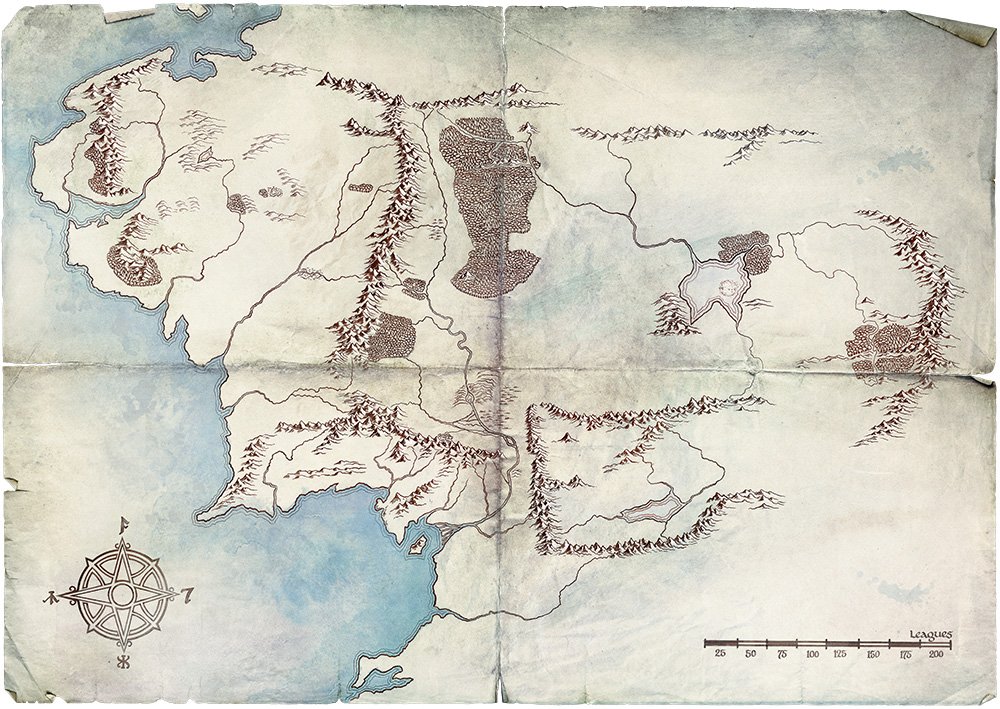
Two days after the first post appeared, a map of Middle-earth appeared along with the first line of Tolkien’s Ring Verse poem: Three rings for the Elven kings under the sky,”. The map itself was blank, but that didn’t stop speculation from one end of the internet to the other.
Top theories and takeaways:
• The mountains on the far east of the map are not on any maps drawn by either J.R.R. Tolkien or his son Christopher, but do appear on a version of a map from The Hobbit movies, and on a map included in Karen Wynn Fonstad’s “The Atlas of Middle-earth.” In the Atlas, they are labeled, “Orocarni (Mountains of the East).” From various sources, we know that “Orocarni” translates to “Red Mountains,” and that Tokien’s references to these mountains appear in “The History of Middle-earth” compiled by Christopher. We don’t know much about them except they were close to the location the Elves awoke.
• The map is definitely from either the 2nd or 3rd Age, as the lands from “The Silmarillion” that existed in the 1st Age are not on the map. This makes sense, because while we don’t know exactly what film rights Amazon prime has, it is believed they don’t have rights to material from “The Silmarillion.” Further, many fans believe the map has to be from the 3rd Age because it seems to reflect the severe deforestation that occurred in the 2nd Age when the Numenoreans harvested trees from Middle-earth to build their ships.
• The compass rose was taken from Fonstad’s “The Atlas of Middle-earth.” The compass points contain some inadvertent errors noticed by keen-eyed Tolkien geeks, explained in-depth on the Tolkien Guide website. However, the takeaway is that Amazon again is making an effort to reference Tolkien and Tolkien-related scholarship. Bravo!
• The ring verse line about the three rings contained a comma at the end, indicating more clues were on the way, and sure enough, they were.
Map 2 and the second line of the Ring Verse (Monday, February 18)
Three days after the appearance of Map 1, a new version of the map appeared with the second line of the Ring Verse (again with a comma at the end): “Seven for the Dwarf-lords in their halls of stone,”. This time, a number of regions names appeared on the map. All of the regions align with Tolkien’s stories and maps, but some names, such as Gondor and Eregion, are missing. Will they appear on future maps? Will the names of cities such as Rivendell and Minas Tirith appear? We don’t know, but it’s a safe bet that the answer is yes.
Top theories and takeaways:
• Many fans immediately noticed that the region widely known as Rohan is designated as Calenardhon. That name was used before Eorl the Young came to the aid of Gondor in the year 2510 of the 3rd Age. For his help, Eorl was awarded most of the area by Cirion, Steward of Gondor, and the Rohirrim renamed it Mark of the Riders, or Rohan. This could indicate that the TV series will take place prior to the region being renamed, not that it narrows things down much, as just short of 6,000 years of history occurred between the start of the 2nd Age and the year 2510 of the 3rd Age.
• If the above theory is correct, it could dash previous rumors that the series will follow a young Aragorn, as Aragorn wasn’t born until the year 2929 T.A., over 400 years after the region was renamed.
• Despite the appearance of the forests on the map looking like they’re from the 3rd Age, the continued use of the Ring Verse in the clues could indicate the story-line will center on the making of the Rings of Power themselves. The Rings of Power were forged by the Elves of Eregion starting around 1500 S.A., culminating with Sauron making the One Ring in the year 1600 S.A.. This theory could be solidified (or not) if Eregion appears on future versions of Amazon’s map.
There you have it! All of the major takeaways, theories and rumors from the clues we have from Amazon so far. Have you heard any other rumors? Let us know!
We recommend staying tuned here and on our facebook page for more up-to-the-minute news and analysis. We also highly recommend tuning in to TORn Tuesdays, where Cliff ‘Quickbeam’ Broadway and sidekick Justin gave an in-depth analysis of the map this past Tuesday, and will continue to bring everyone updates in the future.
Did we just get another tantalizing clue to the content of the upcoming Amazon Prime series on Middle-earth? Earlier today, Amazon tweeted a map of Middle-earth from their The Lord of the Rings on Prime site. The map itself has geographical features, but no text: no names of regions, mountain ranges, etc.