
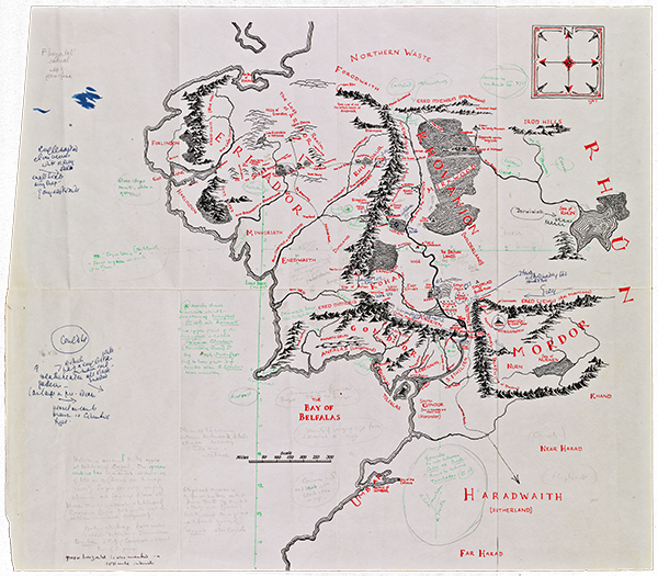
The Bodleian Libraries, home to the largest collection of Tolkien manuscripts and drawings in the world, has acquired a recently discovered map of Middle-earth annotated by J.R.R. Tolkien and artist Pauline Baynes during her early preparations to produce a poster map of Middle-earth that was later published in 1970. The fold-out map was pulled from one of Baynes’ copies of The Lord of the Rings. In order to help her represent Middle-earth as accurately as possible, Tolkien made notes on the map (those in green ink and pencil) regarding the climate of various areas, often equating them to real places in England and Europe, in order to give Baynes an accurate idea of the area’s flora and fauna.
The map was kept by Baynes, who passed away in 2008. It resurfaced in 2015 and was acquired by the Libraries. According to the Libraries:
“The annotated map went unseen for decades until October 2015 when Blackwell’s Rare Books in Oxford put the map on display and offered it for sale. The purchase of the map was funded with assistance from the Victoria & Albert Purchase Grant Fund and the Friends of the Bodleian.
This working document reveals that the creatures which enliven the final poster map – wolves, horses, cattle, elephants and camels – were all suggested by Tolkien and that Baynes drew the animals in the exact locations he specified. ‘Elephants appear in the Great battle outside Minas Tirith (as they did in Italy under Pyrrhus) but they would be in place in the blank squares of Harad – also Camels,’ wrote Tolkien.”
The Bodleian Libraries hopes to put the map on display to the public in the near future – a great reason to plan a special trip! In the meantime, read the fascinating full article here.
